Alabama City Maps
City Maps > AL Cities
 This Alabama city maps page features a map of Montgomery, the state's capital city; it also provides access to detailed maps of cities and other places that are located in Alabama.
Alabama has a land area of 50,644 square miles. The state's population density is about 94.4 residents per square mile.
Montgomery Map
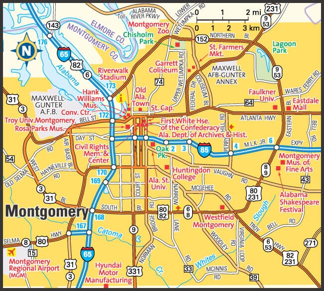
This Montgomery area map shows highways as well as major roads and points of interest in Alabama's capital city.


Montgomery, Alabama Area Map
Alabama Cities and Places *
Each city map page features a locator map plus demographic information about the specific city — as well as a directory of organizations in that Alabama city.- Anniston, Alabama Map - Located at latitude 33.66 north and longitude 85.83 west, the city of Anniston had a population of 22,457 at the 2010 census.
- Auburn, Alabama Map - Located at latitude 32.61 north and longitude 85.48 west, the city of Auburn had a population of 60,258 at the 2010 census.
- Bessemer, Alabama Map - Located at latitude 33.40 north and longitude 86.95 west, the city of Bessemer had a population of 26,949 at the 2010 census.
- Birmingham, Alabama Map - Located at latitude 33.53 north and longitude 86.8 west, the city of Birmingham had a population of 212,247 at the 2010 census.
- Daphne, Alabama Map - Located at latitude 30.60 north and longitude 87.9 west, the city of Daphne had a population of 24,395 at the 2010 census.
- Decatur, Alabama Map - Located at latitude 34.57 north and longitude 86.99 west, the city of Decatur had a population of 55,532 at the 2010 census.
- Dothan, Alabama Map - Located at latitude 31.23 north and longitude 85.41 west, the city of Dothan had a population of 68,409 at the 2010 census.
- Fairhope, Alabama Map - Located at latitude 30.52 north and longitude 87.9 west, the city of Fairhope had a population of 18,089 at the 2010 census.
- Florence, Alabama Map - Located at latitude 34.80 north and longitude 87.68 west, the city of Florence had a population of 40,215 at the 2010 census.
- Foley, Alabama Map - Located at latitude 30.41 north and longitude 87.68 west, the city of Foley had a population of 16,243 at the 2010 census.
- Gadsden, Alabama Map - Located at latitude 34.01 north and longitude 86.01 west, the city of Gadsden had a population of 36,295 at the 2010 census.
- Gulf Shores, Alabama Map - Located at latitude 30.25 north and longitude 87.7 west, the city of Gulf Shores had a population of 10,963 at the 2010 census.
- Huntsville, Alabama Map - Located at latitude 34.70 north and longitude 86.67 west, the city of Huntsville had a population of 188,226 at the 2010 census.
- Madison, Alabama Map - Located at latitude 34.71 north and longitude 86.76 west, the city of Madison had a population of 46,450 at the 2010 census.
- Mobile, Alabama Map - Located at latitude 30.69 north and longitude 88.04 west, the city of Mobile had a population of 194,675 at the 2010 census.
- Montgomery, Alabama Map - Located at latitude 32.37 north and longitude 86.3 west, the city of Montgomery had a population of 200,481 at the 2010 census.
- Muscle Shoals, Alabama Map - Located at latitude 34.74 north and longitude 87.67 west, the city of Muscle Shoals had a population of 13,614 at the 2010 census.
- Orange Beach, Alabama Map - Located at latitude 30.29 north and longitude 87.57 west, the city of Orange Beach had a population of 5,788 at the 2010 census.
- Oxford, Alabama Map - Located at latitude 33.60 north and longitude 85.87 west, the city of Oxford had a population of 21,155 at the 2010 census.
- Pelham, Alabama Map - Located at latitude 33.29 north and longitude 86.81 west, the city of Pelham had a population of 22,699 at the 2010 census.
- Pell City, Alabama Map - Located at latitude 33.59 north and longitude 86.29 west, the city of Pell City had a population of 13,573 at the 2010 census.
- Phenix City, Alabama Map - Located at latitude 32.46 north and longitude 85.03 west, the city of Phenix City had a population of 37,540 at the 2010 census.
- Theodore, Alabama Map - Located at latitude 30.55 north and longitude 88.18 west, the CDP* of Theodore had a population of 6,051 at the 2010 census.
- Trussville, Alabama Map - Located at latitude 33.65 north and longitude 86.56 west, the city of Trussville had a population of 20,702 at the 2010 census.
- Tuscaloosa, Alabama Map - Located at latitude 33.21 north and longitude 87.57 west, the city of Tuscaloosa had a population of 96,122 at the 2010 census.
* A CDP — or census-designated place — is a concentration of population identified by the United States Census Bureau for statistical purposes.
Alabama Images from Pinterest
 |
 |
Major Cities in Each State
Copyright © 2011-2026Zeducorp. All rights reserved.
The Montgomery map hereon is © Globe Turner.
Terms and Conditions.
The Montgomery map hereon is © Globe Turner.
Terms and Conditions.