Tennessee City Maps
City Maps > TN Cities
 This Tennessee city maps page features a map of Nashville, the state's capital city; it also provides access to detailed maps of cities and other places that are located in Tennessee.
Tennessee has a land area of 41,235 square miles. The state's population density is about 153.9 residents per square mile.
Nashville Map
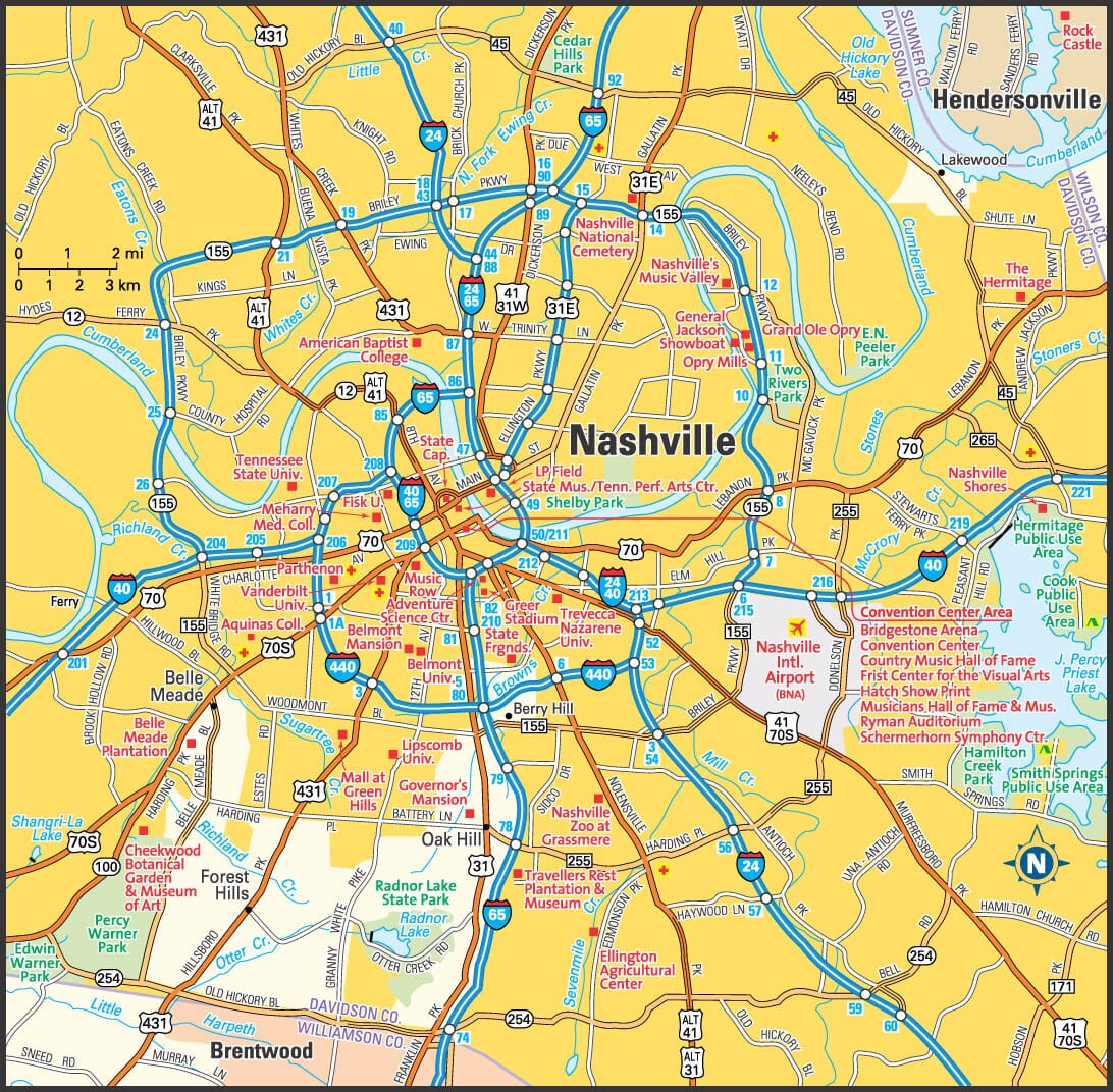
This Nashville area map shows highways as well as major roads and points of interest in Tennessee's capital city.

Nashville, Tennessee Area Map
Tennessee Cities and Places *
Each city map page features a locator map plus demographic information about the specific city — as well as a directory of organizations in that Tennessee city.- Alcoa, Tennessee Map - Located at latitude 35.79 north and longitude 83.97 west, the city of Alcoa had a population of 8,753 at the 2010 census.
- Arlington, Tennessee Map - Located at latitude 35.30 north and longitude 89.66 west, the town of Arlington had a population of 11,634 at the 2010 census.
- Bartlett, Tennessee Map - Located at latitude 35.20 north and longitude 89.87 west, the city of Bartlett had a population of 58,264 at the 2010 census.
- Brentwood, Tennessee Map - Located at latitude 36.03 north and longitude 86.78 west, the city of Brentwood had a population of 40,982 at the 2010 census.
- Bristol, Tennessee Map - Located at latitude 36.60 north and longitude 82.19 west, the city of Bristol had a population of 26,729 at the 2010 census.
- Chattanooga, Tennessee Map - Located at latitude 35.05 north and longitude 85.31 west, the city of Chattanooga had a population of 173,778 at the 2010 census.
- Clarksville, Tennessee Map - Located at latitude 36.53 north and longitude 87.36 west, the city of Clarksville had a population of 146,806 at the 2010 census.
- Cleveland, Tennessee Map - Located at latitude 35.16 north and longitude 84.88 west, the city of Cleveland had a population of 43,182 at the 2010 census.
- Collierville, Tennessee Map - Located at latitude 35.05 north and longitude 89.7 west, the town of Collierville had a population of 48,655 at the 2010 census.
- Columbia, Tennessee Map - Located at latitude 35.62 north and longitude 87.04 west, the city of Columbia had a population of 36,071 at the 2010 census.
- Cookeville, Tennessee Map - Located at latitude 36.16 north and longitude 85.5 west, the city of Cookeville had a population of 31,335 at the 2010 census.
- Franklin, Tennessee Map - Located at latitude 35.93 north and longitude 86.87 west, the city of Franklin had a population of 70,612 at the 2010 census.
- Gallatin, Tennessee Map - Located at latitude 36.39 north and longitude 86.45 west, the city of Gallatin had a population of 33,347 at the 2010 census.
- Gatlinburg, Tennessee Map - Located at latitude 35.71 north and longitude 83.51 west, the city of Gatlinburg had a population of 4,158 at the 2010 census.
- Germantown, Tennessee Map - Located at latitude 35.09 north and longitude 89.81 west, the city of Germantown had a population of 39,267 at the 2010 census.
- Goodlettsville, Tennessee Map - Located at latitude 36.33 north and longitude 86.7 west, the city of Goodlettsville had a population of 16,991 at the 2010 census.
- Hendersonville, Tennessee Map - Located at latitude 36.30 north and longitude 86.62 west, the city of Hendersonville had a population of 55,153 at the 2010 census.
- Jackson, Tennessee Map - Located at latitude 35.61 north and longitude 88.81 west, the city of Jackson had a population of 67,319 at the 2010 census.
- Johnson City, Tennessee Map - Located at latitude 36.34 north and longitude 82.38 west, the city of Johnson City had a population of 65,813 at the 2010 census.
- Kingsport, Tennessee Map - Located at latitude 36.52 north and longitude 82.54 west, the city of Kingsport had a population of 53,028 at the 2010 census.
- Knoxville, Tennessee Map - Located at latitude 35.96 north and longitude 83.92 west, the city of Knoxville had a population of 184,281 at the 2010 census.
- Lebanon, Tennessee Map - Located at latitude 36.21 north and longitude 86.29 west, the city of Lebanon had a population of 29,427 at the 2010 census.
- Maryville, Tennessee Map - Located at latitude 35.76 north and longitude 83.97 west, the city of Maryville had a population of 28,329 at the 2010 census.
- Memphis, Tennessee Map - Located at latitude 35.15 north and longitude 90.05 west, the city of Memphis had a population of 656,861 at the 2010 census.
- Morristown, Tennessee Map - Located at latitude 36.20 north and longitude 83.3 west, the city of Morristown had a population of 29,304 at the 2010 census.
- Mount Juliet, Tennessee Map - Located at latitude 36.20 north and longitude 86.52 west, the city of Mount Juliet had a population of 29,387 at the 2010 census.
- Murfreesboro, Tennessee Map - Located at latitude 35.85 north and longitude 86.39 west, the city of Murfreesboro had a population of 120,954 at the 2010 census.
- Nashville, Tennessee Map - Located at latitude 36.17 north and longitude 86.78 west, the metropolitan government of Nashville had a population of 668,347 at the 2010 census.
- Oak Ridge, Tennessee Map - Located at latitude 35.97 north and longitude 84.29 west, the city of Oak Ridge had a population of 29,303 at the 2010 census.
- Pigeon Forge, Tennessee Map - Located at latitude 35.79 north and longitude 83.55 west, the city of Pigeon Forge had a population of 6,132 at the 2010 census.
- Sevierville, Tennessee Map - Located at latitude 35.87 north and longitude 83.56 west, the city of Sevierville had a population of 16,355 at the 2010 census.
- Smyrna, Tennessee Map - Located at latitude 35.98 north and longitude 86.52 west, the town of Smyrna had a population of 45,274 at the 2010 census.
- Spring Hill, Tennessee Map - Located at latitude 35.74 north and longitude 86.91 west, the city of Spring Hill had a population of 34,269 at the 2010 census.
* A CDP — or census-designated place — is a concentration of population identified by the United States Census Bureau for statistical purposes.
Tennessee Images from Pinterest
 |
 |
Major Cities in Each State
Copyright © 2011-2026Zeducorp. All rights reserved.
The Nashville map hereon is © Globe Turner.
Terms and Conditions.
The Nashville map hereon is © Globe Turner.
Terms and Conditions.