Colorado City Maps
City Maps > CO Cities
 This Colorado city maps page features a map of Denver, the state's capital city; it also provides access to detailed maps of cities and other places that are located in Colorado.
Colorado has a land area of 103,641 square miles. The state's population density is about 48.5 residents per square mile.
Denver Map
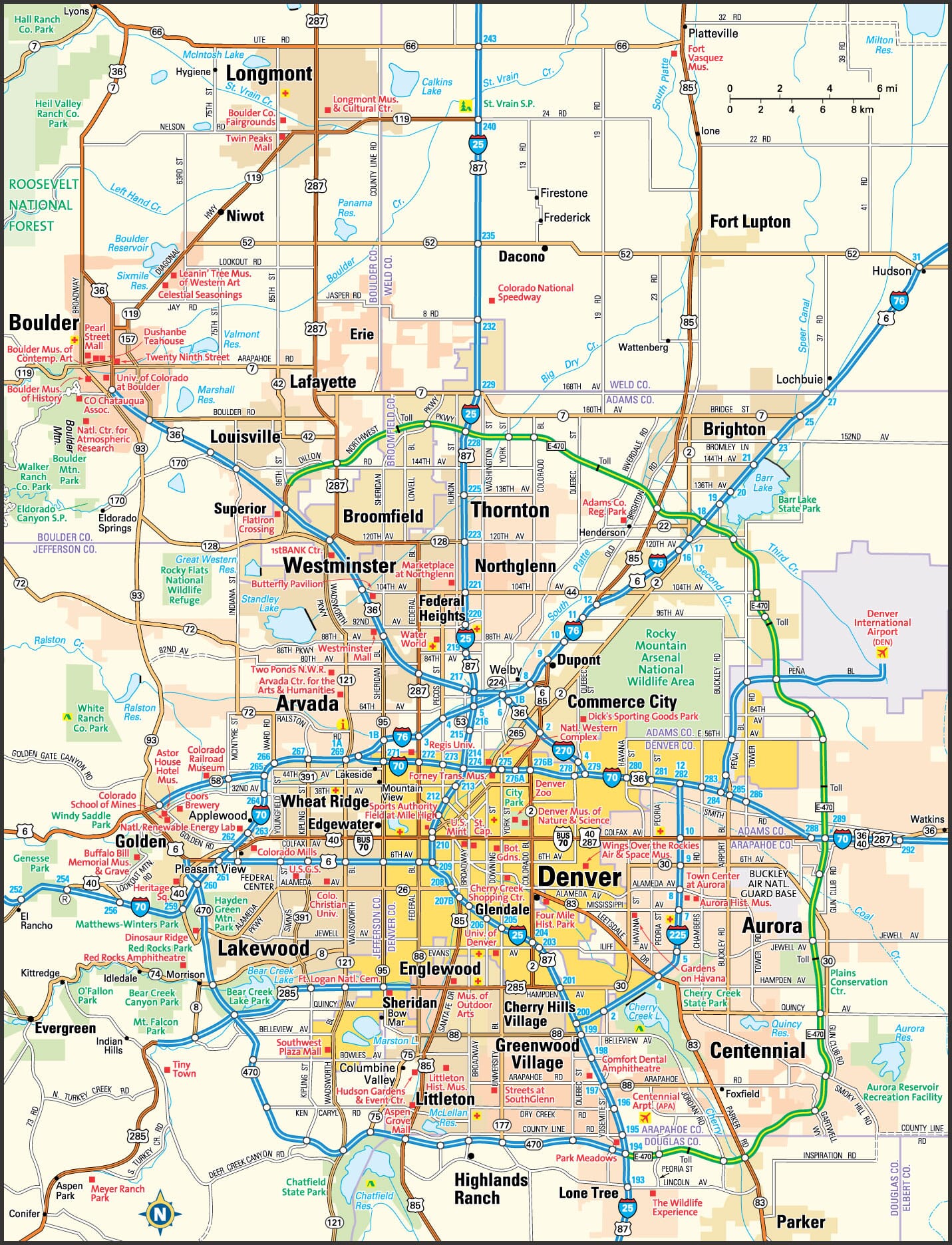
This Denver area map shows highways as well as major roads and points of interest in Colorado's capital city.

Denver, Colorado Area Map
Colorado Cities and Places *
Each city map page features a locator map plus demographic information about the specific city — as well as a directory of organizations in that Colorado city.- Arvada, Colorado Map - Located at latitude 39.83 north and longitude 105.15 west, the city of Arvada had a population of 113,574 at the 2010 census.
- Aspen, Colorado Map - Located at latitude 39.19 north and longitude 106.82 west, the city of Aspen had a population of 6,805 at the 2010 census.
- Aurora, Colorado Map - Located at latitude 39.69 north and longitude 104.69 west, the city of Aurora had a population of 353,108 at the 2010 census.
- Avon, Colorado Map - Located at latitude 39.63 north and longitude 106.52 west, the town of Avon had a population of 6,447 at the 2010 census.
- Basalt, Colorado Map - Located at latitude 39.36 north and longitude 107.02 west, the town of Basalt had a population of 3,919 at the 2010 census.
- Boulder, Colorado Map - Located at latitude 40.01 north and longitude 105.27 west, the city of Boulder had a population of 105,112 at the 2010 census.
- Breckenridge, Colorado Map - Located at latitude 39.48 north and longitude 106.04 west, the town of Breckenridge had a population of 4,749 at the 2010 census.
- Brighton, Colorado Map - Located at latitude 39.96 north and longitude 104.8 west, the city of Brighton had a population of 36,765 at the 2010 census.
- Broomfield, Colorado Map - Located at latitude 39.92 north and longitude 105.09 west, the city of Broomfield had a population of 62,138 at the 2010 census.
- Carbondale, Colorado Map - Located at latitude 39.40 north and longitude 107.21 west, the town of Carbondale had a population of 6,574 at the 2010 census.
- Castle Rock, Colorado Map - Located at latitude 39.37 north and longitude 104.86 west, the town of Castle Rock had a population of 55,747 at the 2010 census.
- Centennial, Colorado Map - Located at latitude 39.58 north and longitude 104.88 west, the city of Centennial had a population of 107,201 at the 2010 census.
- Colorado Springs, Colorado Map - Located at latitude 38.83 north and longitude 104.82 west, the city of Colorado Springs had a population of 445,830 at the 2010 census.
- Commerce City, Colorado Map - Located at latitude 39.81 north and longitude 104.93 west, the city of Commerce City had a population of 51,762 at the 2010 census.
- Dacono, Colorado Map - Located at latitude 40.08 north and longitude 104.94 west, the city of Dacono had a population of 4,544 at the 2010 census.
- Denver, Colorado Map - Located at latitude 39.74 north and longitude 104.98 west, the city of Denver had a population of 663,862 at the 2010 census.
- Durango, Colorado Map - Located at latitude 37.28 north and longitude 107.88 west, the city of Durango had a population of 17,834 at the 2010 census.
- Edwards, Colorado Map - Located at latitude 39.64 north and longitude 106.59 west, the CDP* of Edwards had a population of 9,385 at the 2010 census.
- Englewood, Colorado Map - Located at latitude 39.65 north and longitude 104.99 west, the city of Englewood had a population of 32,480 at the 2010 census.
- Erie, Colorado Map - Located at latitude 40.04 north and longitude 105.04 west, the town of Erie had a population of 20,493 at the 2010 census.
- Estes Park, Colorado Map - Located at latitude 40.38 north and longitude 105.52 west, the town of Estes Park had a population of 6,165 at the 2010 census.
- Evergreen, Colorado Map - Located at latitude 39.63 north and longitude 105.32 west, the CDP* of Evergreen had a population of 8,690 at the 2010 census.
- Fort Collins, Colorado Map - Located at latitude 40.59 north and longitude 105.08 west, the city of Fort Collins had a population of 156,480 at the 2010 census.
- Glenwood Springs, Colorado Map - Located at latitude 39.55 north and longitude 107.32 west, the city of Glenwood Springs had a population of 9,840 at the 2010 census.
- Golden, Colorado Map - Located at latitude 39.76 north and longitude 105.22 west, the city of Golden had a population of 20,201 at the 2010 census.
- Grand Junction, Colorado Map - Located at latitude 39.06 north and longitude 108.55 west, the city of Grand Junction had a population of 60,210 at the 2010 census.
- Greeley, Colorado Map - Located at latitude 40.42 north and longitude 104.71 west, the city of Greeley had a population of 98,596 at the 2010 census.
- Gypsum, Colorado Map - Located at latitude 39.65 north and longitude 106.95 west, the town of Gypsum had a population of 6,797 at the 2010 census.
- Lafayette, Colorado Map - Located at latitude 39.99 north and longitude 105.09 west, the city of Lafayette had a population of 27,081 at the 2010 census.
- Lakewood, Colorado Map - Located at latitude 39.70 north and longitude 105.08 west, the city of Lakewood had a population of 149,643 at the 2010 census.
- Littleton, Colorado Map - Located at latitude 39.59 north and longitude 105.02 west, the city of Littleton had a population of 44,669 at the 2010 census.
- Longmont, Colorado Map - Located at latitude 40.17 north and longitude 105.1 west, the city of Longmont had a population of 90,237 at the 2010 census.
- Louisville, Colorado Map - Located at latitude 39.98 north and longitude 105.13 west, the city of Louisville had a population of 20,112 at the 2010 census.
- Loveland, Colorado Map - Located at latitude 40.40 north and longitude 105.07 west, the city of Loveland had a population of 72,651 at the 2010 census.
- Manitou Springs, Colorado Map - Located at latitude 38.86 north and longitude 104.92 west, the city of Manitou Springs had a population of 5,314 at the 2010 census.
- Parker, Colorado Map - Located at latitude 39.52 north and longitude 104.76 west, the town of Parker had a population of 49,857 at the 2010 census.
- Pueblo, Colorado Map - Located at latitude 38.25 north and longitude 104.61 west, the city of Pueblo had a population of 108,423 at the 2010 census.
- Steamboat Springs, Colorado Map - Located at latitude 40.48 north and longitude 106.83 west, the city of Steamboat Springs had a population of 12,260 at the 2010 census.
- Vail, Colorado Map - Located at latitude 39.64 north and longitude 106.37 west, the town of Vail had a population of 5,328 at the 2010 census.
- Westminster, Colorado Map - Located at latitude 39.88 north and longitude 105.06 west, the city of Westminster had a population of 112,090 at the 2010 census.
- Wheat Ridge, Colorado Map - Located at latitude 39.77 north and longitude 105.08 west, the city of Wheat Ridge had a population of 31,034 at the 2010 census.
- Windsor, Colorado Map - Located at latitude 40.48 north and longitude 104.92 west, the town of Windsor had a population of 21,106 at the 2010 census.
* A CDP — or census-designated place — is a concentration of population identified by the United States Census Bureau for statistical purposes.
Colorado Images from Pinterest
 |
 |
Major Cities in Each State
Copyright © 2011-2026Zeducorp. All rights reserved.
The Denver map hereon is © Globe Turner.
Terms and Conditions.
The Denver map hereon is © Globe Turner.
Terms and Conditions.