Nevada City Maps
City Maps > NV Cities
 This Nevada city maps page features a map of the state's capital city; it also provides access to detailed maps of cities and other places that are located in Nevada.
Nevada has a land area of 109,780 square miles. The state is sparsely populated, with about 24.6 residents per square mile.
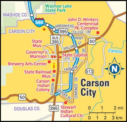
Carson City Map
This Carson City area map shows highways as well as major roads and points of interest in Nevada's capital city.

Carson City, Nevada Area Map
Nevada Cities and Places *
Each city map page features a locator map plus demographic information about the specific city — as well as a directory of organizations in that Nevada city.- Carson City, Nevada Map - Located at latitude 39.16 north and longitude 119.77 west, the other of Carson City had a population of 54,522 at the 2010 census.
- Henderson, Nevada Map - Located at latitude 36.04 north and longitude 114.98 west, the city of Henderson had a population of 277,440 at the 2010 census.
- Incline Village, Nevada Map - Located at latitude 39.25 north and longitude 119.97 west, the CDP* of Incline Village had a population of 8,389 at the 2010 census.
- Las Vegas, Nevada Map - Located at latitude 36.17 north and longitude 115.14 west, the city of Las Vegas had a population of 613,599 at the 2010 census.
- Mesquite, Nevada Map - Located at latitude 36.81 north and longitude 114.07 west, the city of Mesquite had a population of 16,970 at the 2010 census.
- Minden, Nevada Map - Located at latitude 38.95 north and longitude 119.77 west, the CDP* of Minden had a population of 3,408 at the 2010 census.
- North Las Vegas, Nevada Map - Located at latitude 36.20 north and longitude 115.12 west, the city of North Las Vegas had a population of 230,788 at the 2010 census.
- Reno, Nevada Map - Located at latitude 39.53 north and longitude 119.81 west, the city of Reno had a population of 236,995 at the 2010 census.
- Sparks, Nevada Map - Located at latitude 39.53 north and longitude 119.75 west, the city of Sparks had a population of 94,708 at the 2010 census.
* A CDP — or census-designated place — is a concentration of population identified by the United States Census Bureau for statistical purposes.
Nevada Images from Pinterest
 |
 |
Major Cities in Each State
Copyright © 2011-2026Zeducorp. All rights reserved.
The Carson City map hereon is © Globe Turner.
Terms and Conditions.
The Carson City map hereon is © Globe Turner.
Terms and Conditions.