Rhode Island City Maps
City Maps > RI Cities
 This Rhode Island city maps page features a map of Providence, the state's capital city; it also provides access to detailed maps of cities and other places that are located in Rhode Island.
Rhode Island has a land area of 1,034 square miles. The state is densely populated, with about 1,018.4 residents per square mile.
Providence Map
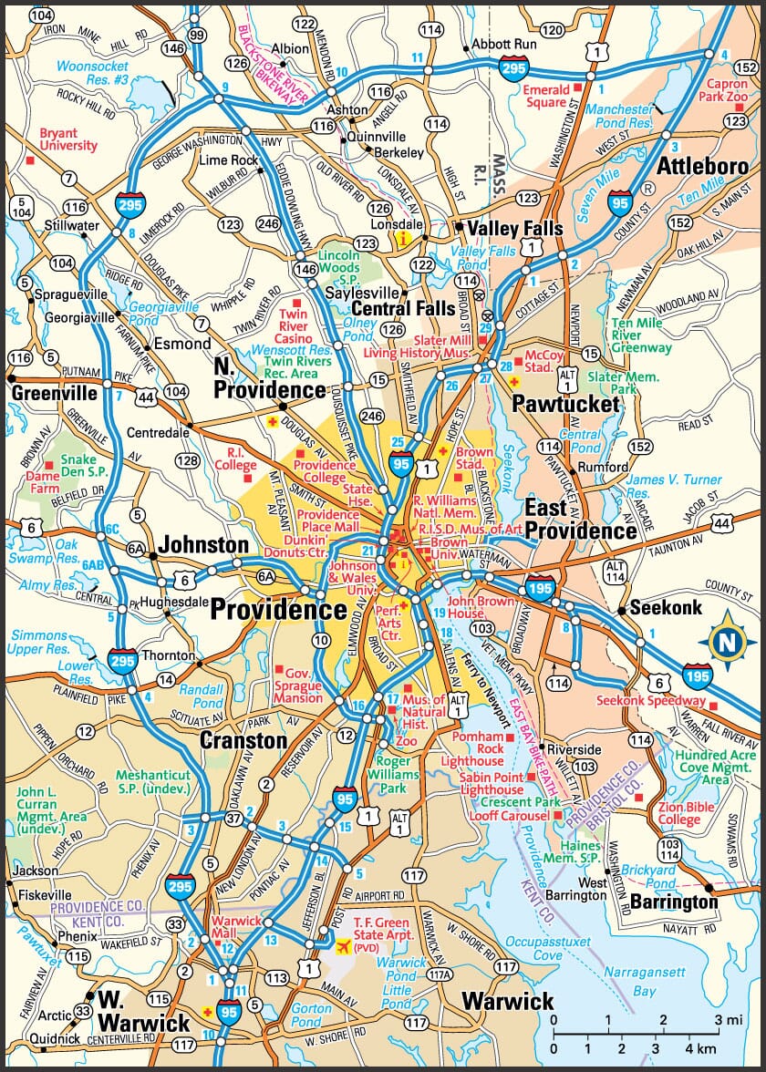
This Providence area map shows highways as well as major roads and points of interest in Rhode Island's capital city.

Providence, Rhode Island Area Map
Rhode Island Cities and Places *
Each city map page features a locator map plus demographic information about the specific city — as well as a directory of organizations in that Rhode Island city.- Bristol, Rhode Island Map - Located at latitude 41.68 north and longitude 71.27 west, the town of Bristol had a population of 22,332 at the 2010 census.
- Cranston, Rhode Island Map - Located at latitude 41.78 north and longitude 71.44 west, the city of Cranston had a population of 81,037 at the 2010 census.
- East Greenwich, Rhode Island Map - Located at latitude 41.64 north and longitude 71.51 west, the town of East Greenwich had a population of 13,147 at the 2010 census.
- East Providence, Rhode Island Map - Located at latitude 41.81 north and longitude 71.37 west, the city of East Providence had a population of 47,331 at the 2010 census.
- Johnston, Rhode Island Map - Located at latitude 41.83 north and longitude 71.52 west, the town of Johnston had a population of 29,144 at the 2010 census.
- Middletown, Rhode Island Map - Located at latitude 41.52 north and longitude 71.28 west, the town of Middletown had a population of 16,105 at the 2010 census.
- Narragansett, Rhode Island Map - Located at latitude 41.41 north and longitude 71.48 west, the town of Narragansett had a population of 15,705 at the 2010 census.
- Newport, Rhode Island Map - Located at latitude 41.49 north and longitude 71.31 west, the city of Newport had a population of 24,089 at the 2010 census.
- North Kingstown, Rhode Island Map - Located at latitude 41.57 north and longitude 71.45 west, the town of North Kingstown had a population of 26,291 at the 2010 census.
- Pawtucket, Rhode Island Map - Located at latitude 41.88 north and longitude 71.38 west, the city of Pawtucket had a population of 71,499 at the 2010 census.
- Providence, Rhode Island Map - Located at latitude 41.82 north and longitude 71.41 west, the city of Providence had a population of 179,154 at the 2010 census.
- Smithfield, Rhode Island Map - Located at latitude 41.90 north and longitude 71.53 west, the town of Smithfield had a population of 21,507 at the 2010 census.
- Wakefield, Rhode Island Map - Located at latitude 41.44 north and longitude 71.5 west, the CDP* of Wakefield had a population of 8,911 at the 2010 census.
- Warwick, Rhode Island Map - Located at latitude 41.70 north and longitude 71.42 west, the city of Warwick had a population of 81,963 at the 2010 census.
- Westerly, Rhode Island Map - Located at latitude 41.33 north and longitude 71.78 west, the town of Westerly had a population of 22,731 at the 2010 census.
- Woonsocket, Rhode Island Map - Located at latitude 42.00 north and longitude 71.51 west, the city of Woonsocket had a population of 41,228 at the 2010 census.
* A CDP — or census-designated place — is a concentration of population identified by the United States Census Bureau for statistical purposes.
Rhode Island Images from Pinterest
 |
 |
Major Cities in Each State
Copyright © 2011-2026Zeducorp. All rights reserved.
The Providence map hereon is © Globe Turner.
Terms and Conditions.
The Providence map hereon is © Globe Turner.
Terms and Conditions.