Arizona City Maps
City Maps > AZ Cities
 This Arizona city maps page features a map of Phoenix, the state's capital city; it also provides access to detailed maps of cities and other places that are located in Arizona.
Arizona has a land area of 113,595 square miles. The state's population density is about 56.3 residents per square mile.
Phoenix Map
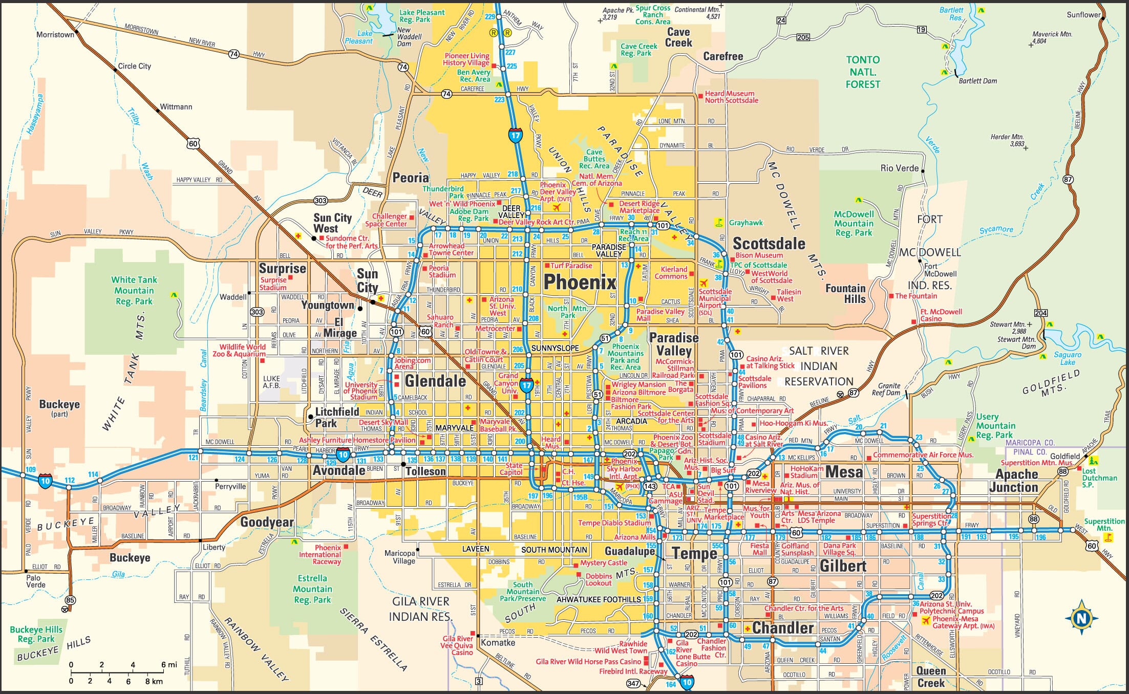
This Phoenix area map shows highways as well as major roads and points of interest in Arizona's capital city.

Phoenix, Arizona Area Map
Arizona Cities and Places *
Each city map page features a locator map plus demographic information about the specific city — as well as a directory of organizations in that Arizona city.- Apache Junction, Arizona Map - Located at latitude 33.40 north and longitude 111.54 west, the city of Apache Junction had a population of 38,131 at the 2010 census.
- Avondale, Arizona Map - Located at latitude 33.44 north and longitude 112.35 west, the city of Avondale had a population of 79,646 at the 2010 census.
- Chandler, Arizona Map - Located at latitude 33.31 north and longitude 111.84 west, the city of Chandler had a population of 254,276 at the 2010 census.
- Flagstaff, Arizona Map - Located at latitude 35.20 north and longitude 111.65 west, the city of Flagstaff had a population of 68,785 at the 2010 census.
- Gilbert, Arizona Map - Located at latitude 33.35 north and longitude 111.79 west, the town of Gilbert had a population of 239,277 at the 2010 census.
- Glendale, Arizona Map - Located at latitude 33.54 north and longitude 112.19 west, the city of Glendale had a population of 237,517 at the 2010 census.
- Goodyear, Arizona Map - Located at latitude 33.44 north and longitude 112.36 west, the city of Goodyear had a population of 75,664 at the 2010 census.
- Green Valley, Arizona Map - Located at latitude 31.85 north and longitude 110.99 west, the CDP* of Green Valley had a population of 22,519 at the 2010 census.
- Lake Havasu City, Arizona Map - Located at latitude 34.48 north and longitude 114.32 west, the city of Lake Havasu City had a population of 53,103 at the 2010 census.
- Litchfield Park, Arizona Map - Located at latitude 33.49 north and longitude 112.36 west, the city of Litchfield Park had a population of 5,392 at the 2010 census.
- Mesa, Arizona Map - Located at latitude 33.42 north and longitude 111.82 west, the city of Mesa had a population of 464,704 at the 2010 census.
- Peoria, Arizona Map - Located at latitude 33.79 north and longitude 112.31 west, the city of Peoria had a population of 166,934 at the 2010 census.
- Phoenix, Arizona Map - Located at latitude 33.45 north and longitude 112.07 west, the city of Phoenix had a population of 1,537,058 at the 2010 census.
- Prescott, Arizona Map - Located at latitude 34.54 north and longitude 112.47 west, the city of Prescott had a population of 40,958 at the 2010 census.
- Prescott Valley, Arizona Map - Located at latitude 34.61 north and longitude 112.32 west, the town of Prescott Valley had a population of 41,075 at the 2010 census.
- Queen Creek, Arizona Map - Located at latitude 33.24 north and longitude 111.64 west, the town of Queen Creek had a population of 32,236 at the 2010 census.
- Scottsdale, Arizona Map - Located at latitude 33.51 north and longitude 111.9 west, the city of Scottsdale had a population of 230,512 at the 2010 census.
- Sedona, Arizona Map - Located at latitude 34.86 north and longitude 111.8 west, the city of Sedona had a population of 10,281 at the 2010 census.
- Sierra Vista, Arizona Map - Located at latitude 31.55 north and longitude 110.3 west, the city of Sierra Vista had a population of 43,806 at the 2010 census.
- Sun City West, Arizona Map - Located at latitude 33.66 north and longitude 112.34 west, the CDP* of Sun City West had a population of 24,066 at the 2010 census.
- Surprise, Arizona Map - Located at latitude 33.63 north and longitude 112.33 west, the city of Surprise had a population of 126,275 at the 2010 census.
- Tempe, Arizona Map - Located at latitude 33.41 north and longitude 111.91 west, the city of Tempe had a population of 172,816 at the 2010 census.
- Tucson, Arizona Map - Located at latitude 32.22 north and longitude 110.93 west, the city of Tucson had a population of 527,972 at the 2010 census.
- Yuma, Arizona Map - Located at latitude 32.73 north and longitude 114.62 west, the city of Yuma had a population of 93,400 at the 2010 census.
* A CDP — or census-designated place — is a concentration of population identified by the United States Census Bureau for statistical purposes.
Arizona Images from Pinterest
 |
 |
Major Cities in Each State
Copyright © 2011-2026Zeducorp. All rights reserved.
The Phoenix map hereon is © Globe Turner.
Terms and Conditions.
The Phoenix map hereon is © Globe Turner.
Terms and Conditions.