Iowa City Maps
City Maps > IA Cities
 This Iowa city maps page features a map of Des Moines, the state's capital city; it also provides access to detailed maps of cities and other places that are located in Iowa.
Iowa has a land area of 55,858 square miles. The state's population density is about 54.5 residents per square mile.
Des Moines Map
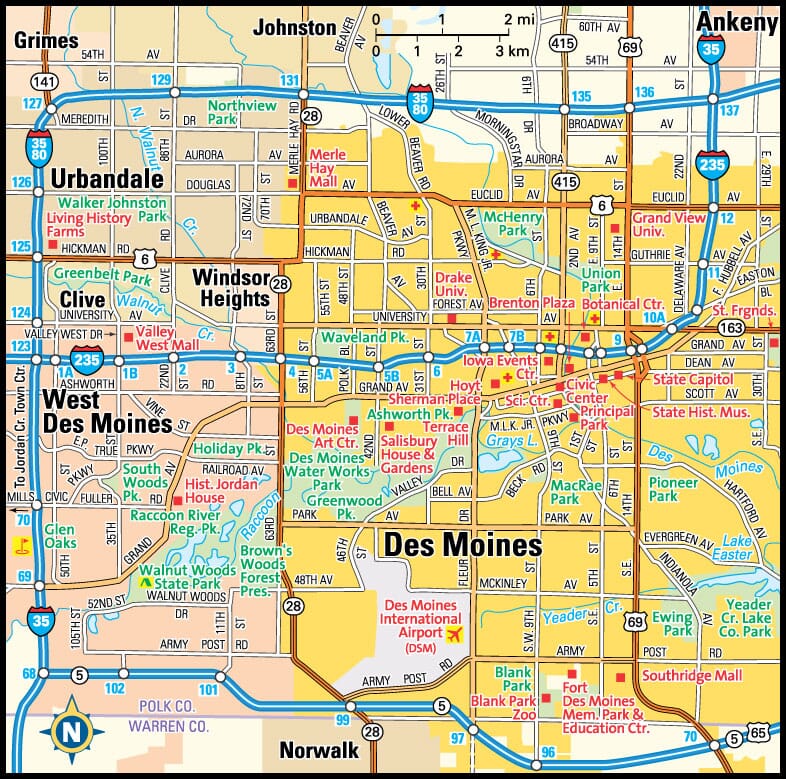
This Des Moines area map shows highways as well as major roads and points of interest in Iowa's capital city.

Des Moines, Iowa Area Map
Iowa Cities and Places *
Each city map page features a locator map plus demographic information about the specific city — as well as a directory of organizations in that Iowa city.- Ames, Iowa Map - Located at latitude 42.03 north and longitude 93.62 west, the city of Ames had a population of 63,266 at the 2010 census.
- Ankeny, Iowa Map - Located at latitude 41.73 north and longitude 93.61 west, the city of Ankeny had a population of 53,801 at the 2010 census.
- Bettendorf, Iowa Map - Located at latitude 41.52 north and longitude 90.52 west, the city of Bettendorf had a population of 35,122 at the 2010 census.
- Cedar Falls, Iowa Map - Located at latitude 42.53 north and longitude 92.45 west, the city of Cedar Falls had a population of 40,859 at the 2010 census.
- Cedar Rapids, Iowa Map - Located at latitude 42.01 north and longitude 91.64 west, the city of Cedar Rapids had a population of 129,195 at the 2010 census.
- Clive, Iowa Map - Located at latitude 41.61 north and longitude 93.8 west, the city of Clive had a population of 17,052 at the 2010 census.
- Coralville, Iowa Map - Located at latitude 41.68 north and longitude 91.58 west, the city of Coralville had a population of 20,349 at the 2010 census.
- Council Bluffs, Iowa Map - Located at latitude 41.26 north and longitude 95.86 west, the city of Council Bluffs had a population of 62,245 at the 2010 census.
- Davenport, Iowa Map - Located at latitude 41.52 north and longitude 90.58 west, the city of Davenport had a population of 102,448 at the 2010 census.
- Des Moines, Iowa Map - Located at latitude 41.57 north and longitude 93.61 west, the city of Des Moines had a population of 209,220 at the 2010 census.
- Dubuque, Iowa Map - Located at latitude 42.50 north and longitude 90.66 west, the city of Dubuque had a population of 58,436 at the 2010 census.
- Eldridge, Iowa Map - Located at latitude 41.66 north and longitude 90.58 west, the city of Eldridge had a population of 6,162 at the 2010 census.
- Iowa City, Iowa Map - Located at latitude 41.66 north and longitude 91.53 west, the city of Iowa City had a population of 73,415 at the 2010 census.
- Mason City, Iowa Map - Located at latitude 43.15 north and longitude 93.2 west, the city of Mason City had a population of 27,458 at the 2010 census.
- Sioux City, Iowa Map - Located at latitude 42.50 north and longitude 96.39 west, the city of Sioux City had a population of 82,517 at the 2010 census.
- Urbandale, Iowa Map - Located at latitude 41.64 north and longitude 93.78 west, the city of Urbandale had a population of 43,150 at the 2010 census.
- Waterloo, Iowa Map - Located at latitude 42.49 north and longitude 92.34 west, the city of Waterloo had a population of 68,364 at the 2010 census.
- West Des Moines, Iowa Map - Located at latitude 41.55 north and longitude 93.78 west, the city of West Des Moines had a population of 63,325 at the 2010 census.
* A CDP — or census-designated place — is a concentration of population identified by the United States Census Bureau for statistical purposes.
Iowa Images from Pinterest
 |
 |
Major Cities in Each State
Copyright © 2011-2026Zeducorp. All rights reserved.
The Des Moines map hereon is © Globe Turner.
Terms and Conditions.
The Des Moines map hereon is © Globe Turner.
Terms and Conditions.